
Hawaii is renowned for its beautiful Pacific beaches and tropical climate - a world apart for the people from the American mainland. It provides an escape from their severe winter. Though far away, Hawaii, being one of the fifty States of the United States, makes it a hassle free destination for them - no currency changes, driving restrictions or medical insurance worries. But what I noticed was the horde of disciplined Japanese visitors outnumbering the boisterous Americans.
But the fact is there is much more to these islands, than their fame as a tropical paradise.
But the fact is there is much more to these islands, than their fame as a tropical paradise.
One of the main aims of our visit to Hawaii was to go up the volcanic mountain of Mauna Kea. We also had plans to see the other volcanic sites, especially the Volcanoes National Park, else where on the islands.
In fact Hawaii itself was formed from the volcanic eruptions in the Pacific, millions of years ago. The Hawaii state of USA, comprises of hundreds of islands spread over 2,400 km. But the the eight main islands on the eastern end of the archipelago, are the ones popularly considered as Hawaii.
These islands have native names - Niʻihau, Kauaʻi, Oʻahu, Molokaʻi, Lānaʻi, Kahoʻolawe, Maui and the island of Hawaiʻi.
We visited O'hau, the touristy & glamorous island famous for Waikiki beach and the biggest one named Hawaii itself, but almost always called by the natives as the 'Big Island' to differentiate it from the US State of Hawaii.
We visited O'hau, the touristy & glamorous island famous for Waikiki beach and the biggest one named Hawaii itself, but almost always called by the natives as the 'Big Island' to differentiate it from the US State of Hawaii.
Moloka'i too was high up in the agenda. It was to Molokai, in 19th century- when there was no cure for leprosy, the unfortunate patients were forcefully exiled, to die a terrible death, without care or concern.
Leprosy then meant certain death. An young priest named Fr. Damien- later raised to sainthood by the Pope- volunteered to serve the lepers and after sixteen years of caring for the lepers, contracted of the disease himself , and died in 1889 at the age of 49.
I had learned about him in the social studies lessons in my school days and so to me Hawaii was always associated with Fr. Damien's sacrifice.
Unfortunately we couldn't make it to his sanatorium, due to time constraints.
But on my flight from Honolulu to the Big Island and back - both times- I looked out for and identified Molokai as it emerged and passed, my window, from high above the green island whose shores were being constantly washed by the pacific waves, as if in perpetual salute to the kind heart that served humanity and made the ultimate sacrifice for the desolate and the dispossessed.


 | |||||||||||||||||||||||||||||||
| With the disease - in the last days. |
--------------------------------------------------------------------------------------------------------------------
Let me come back to the visit.

Our destinations, Mauna Kea volcano and the Volcanoes National Park - both are situated here. On arrival we hired a Nissan Altima car and went about executing our plan.
Here I describe our visit to Mauna Kea, the tallest peak.
Our original idea was to walk up the mountain - which several adventurist tourists do, but was abandoned for a car trip, for two reasons - paucity of time and the severe weather conditions at the summit in the February winter season.

In Hawaiian language Mauna Kea means White Mountain, perhaps because of the winter ice cover.
The summit of Mauna Kea is 4,200 m [ 13,900 ft ] above sea level. It is very cold and windy at the top. The oxygen supply also begins to dwindle as you go up. Situated higher than the earth's tree line, not a blade of grass is seen at the top.
The air is so clean - that the best, observatory in the world is set up here.

One the good things about US Park Services is the quality of service they provide to visitors in helping them choose the best options within the time at their disposal.

The warnings posted at the Onizuka Visitor Center for International Astronomy,
at 9300 feet ( 3000 m. ) above sea level. There is a good video tour in the center hall, that gives the visitor an idea about the place.
A typical American Tourist Visitor Center will have Range Officer's desk, at most places a short free guided tours around the facility, restaurants, and without fail, the souvenir shops selling the monument's attractions like caps, picture cards and fridge magnets, printed mugs and other trivia.


Just beyond the visitor center, the tarred road ends. Unpaved road takes you up the barren heights.
As you approach the earth's tree-line you can see the the last of the vegetation disappear behind you.
As you approach the earth's tree-line you can see the the last of the vegetation disappear behind you.

As we reach the summit and turn a curve, the huge telescopes come into view.
While standing at 13,900 ft (4 km.) above sea level; for the first time in my life, I experience earth's rarefied atmosphere. The shortage of oxygen is discernible.
This telescope facility is administered by University of Hawaii, with the support of several participating countries like UK, Japan, France and institutions like NASA. Being in the middle of the Pacific Ocean, isolated from dust and pollution, Mauna Kea is considered to be the best locations on earth for ground-based astronomy. More new satellites outside solar system has been discovered here, than any where else from ground based observatories.

The Volcano and its crater. Mauna Kea last erupted 4,600 years ago.


Shortly, I intend to post a YouTube video in Malayalam, to demo, how this app works.
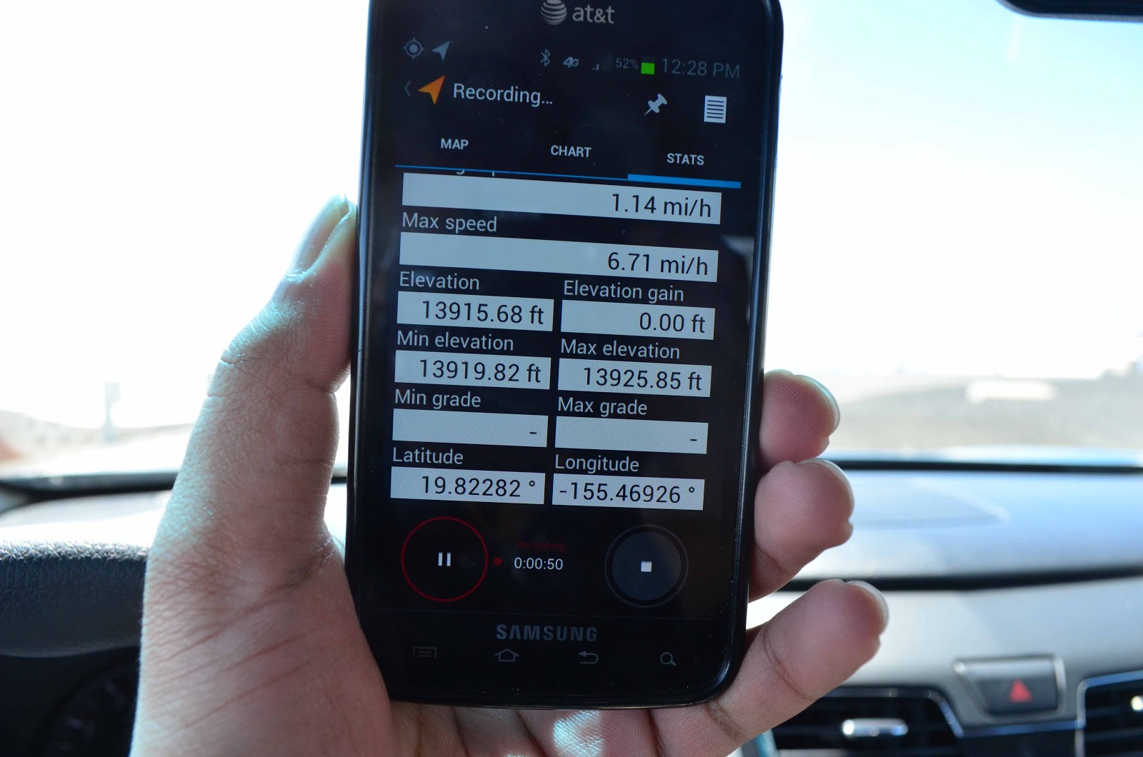
Mean while, Mathew's phone display the rate of ascend.
At this height you can clearly feel the effect of high altitude, that we have only read about.
At this height you can clearly feel the effect of high altitude, that we have only read about.

Irrespective of the huge investment and the wait period for scientists to use the research facility , this place allows visitors to take a free look through the telescope, Monday through Friday, during the day time.
I feet unlucky to have arrived on a Saturday and thereby missing the golden opportunity to look through one of the most powerful telescope on earth.
When I say it aloud, shivering in the bitter cold of the blasting wind, my companion disagrees.
"We are lucky to be here", is his short comment.

The design of two telescopes displayed inside the closed facility.
I stay here a while before stepping into the merciless environment outside.
I stay here a while before stepping into the merciless environment outside.

Mars like landscape, nothing green anywhere.
Mauna Kea is presently a dormant volcano, having last erupted about 4,500 years ago.
However, the scientists predicts that it is likely to erupt again.
Mauna Kea is presently a dormant volcano, having last erupted about 4,500 years ago.
However, the scientists predicts that it is likely to erupt again.

On the way down, the grass reappear.

A peculiar flowering plant, at about 9000 feet, near the visitor center.
While they wave in the wind, it appears to be a thousand snakes collectively rearing their head up.
Later I find its name- Mullein.
While they wave in the wind, it appears to be a thousand snakes collectively rearing their head up.
Later I find its name- Mullein.

Down hill, back on main road, we stop a while to look at the volcano from the bottom,
before we go on our way to Kailua Kona on the west coast.
before we go on our way to Kailua Kona on the west coast.

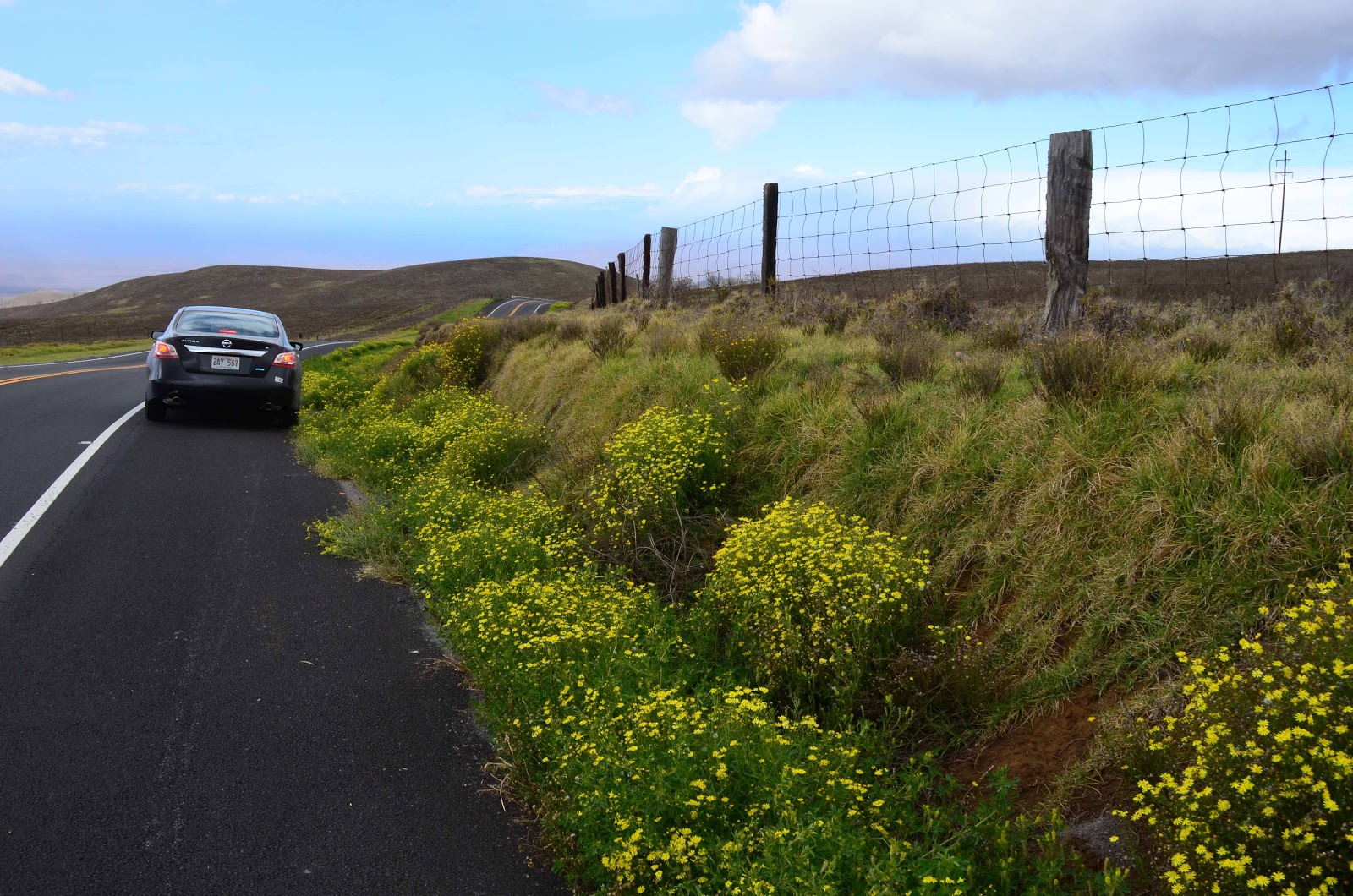
Lonely highway called Saddle Road that connects Hilo & Kona.
Though, by US main-land standards, it is single lane and narrow -
the road is well built and properly maintained, making the ride fast and pleasurable.
Though, by US main-land standards, it is single lane and narrow -
the road is well built and properly maintained, making the ride fast and pleasurable.
On the highway's edge a long line of plants called " Fire weed" that form a natural flower bed,
decorating the road like a wedding podium.
decorating the road like a wedding podium.

Close up of Fireweed.
Fireweed is particularly disliked by the farmers here as it contains a pyrrolizidine alkaloid which can cause liver damage in animals. There have been reports of cattle dying as a result of exposure to the plant. Something like the വിഷപ്പയര് in our rubber plantations.
 Barren lands at the foot of Kea.
Beyond Kea's foot, on some part of the road travelers are not allowed to stop owing to
US military installations.

Fireweed is particularly disliked by the farmers here as it contains a pyrrolizidine alkaloid which can cause liver damage in animals. There have been reports of cattle dying as a result of exposure to the plant. Something like the വിഷപ്പയര് in our rubber plantations.

Beyond Kea's foot, on some part of the road travelers are not allowed to stop owing to
US military installations.

As one nears the west coast the land scape changes. It is always windy as the Pacific blows from the north, raking up huge waves. So north coast of this island is a wind surfers paradise.

Finally we reach the west coast. The mighty Pacific greet us from the horizon.
 A small town appears. The coast is tropical and windy.
The coconut tress are ever flagging wildly.

The coconut tress are ever flagging wildly.

From Kona we go to the north coast, famous for fabulous beaches, that gives Hawaii its fame.

The ferocious winds drive up the surf high over the surfers and surfers are
always around with their board.
The wind-surfing world completions are held here.

At Kona city as the day ends.
The old city airport abandoned for a new one outside the city is on the sea shore,
It is now a beach side park. A good place to view the Pacific sunset.
And also the time for us to go back to our hotel in Hilo. A long ride back all across the island.

Kona city by the night; view from the abandoned runway.
Coffee grown in the Kona region is very famous. Our hotel in Hilo, had provided Kona Beans coffee pouch for the room's electric coffee percolator.
I am a coffee-man and liked its aroma and strength.

Soon heavy mist shrouded our car. We had not thought of this possibility. Visibility was merely 20 to 30 feet. Our car did not have fog lamps. As we got near to the foot of Mauna Kea, visbility dropped further.

But the good pavement markings of the road helped us to navigate slowly across the foot of Mauna Kea, when the rain suddenly cleared the road for us.
Thankfully we drove to hotel, had a nice dinner and went to bed to catch the early morning flight to O'ahu. But before that we have to return the rental car, to its station in front of the airport arrival. If we arrive before they open at 6 AM, all we have to do is to deposit the key into the drop box of the kiosk. Hilo has a small airport, with old style looks.

Hilo airport arrival area.
This terminal building is mostly made with thick wooden tresses and planks
of the native trees, giving it an old world style.
of the native trees, giving it an old world style.

The Hawaiian Airline's Boeing 717, that will take us back to O'ahu.
Not many have heard of Boeing 717, correct ? There is a story to it. The aircraft was designed to be marketed by McDonnell Douglas as the MD-95. But before production, McDonnell Douglas and Boeing merged in 1997 and so the first planes entered service in 1999 as the Boeing 717.
It is the work horse of the local Hawaiian Airlines, that cater to short distance hops between islands.
Next week :
The Volcanoes National Park of Hawai'i.
and later to end this series,
Pearl Harbour, Honolulu & Waikiki beach of O'ahu.
The Volcanoes National Park of Hawai'i.
and later to end this series,
Pearl Harbour, Honolulu & Waikiki beach of O'ahu.
No comments:
Post a Comment