Sunday, September 30, 2012

Day 4 The last day of the Canyon Tour - Zion National Park


US ROUTE 89 from Page arrives at  Kanab, a small town where we lodged for the last day of the canyon tour. In the morning  we will ride through the Zion National Park ( green area, center of the map) and then take Interstate 15( transverse yellow road on the left of the map ) to Hoover Dam out side Las Vegas. From Vegas we'll fly back to New York by the 10 PM Delta Flight.


Typical sight on the road from Kanab to Zion Park


A Pizza joint just outside the Park.

 Welcome Sign. You can see the the beginning of the  typical limestone rocks.

   
 Entrance to the Park where you take the tickets for the car.

 Lime stone rock formations. You can ride the entire length of the park in your car
 and go out through the other entrance. Gaze up at massive sandstone cliffs of cream, pink, and red that soar into a brilliant blue sky.

 Even the roads is surfaced to match the colour of the enviorment.


 Travelers get out to make side tours through the Park to see water falls and valleys.
The Grand Canyon  is abut 150 miles to its south.
  Zion Canyon Scenic Drive and Echo Canyon are not far of the East Rim Trail.
You have to spend at least 3 days here to do justice to the place.


Zion National Park features stunning scenery, sandstone cliffs which are among the highest in the world, with diverse plant and animal communities. 
Once home to ancient Indian tribes  Puebloan & Paiute and later 
white Mormon pioneer settlers.

 I just don't know if these flowers are also seen sometimes on our roadsides. Looks so similar.
The Road passes through a couple of tunnels.

Samall tunnel, can see the other end


View from the inside of the longer tunnel


This tunnel has a side windows to the valley side
A few miles down the road, this opening can be seen from the valley below.

Outside
Winding road.
This is the  paths where ancient native people and pioneers of Americam settement walked.
Taking a picture of the tunnel window


Exit of the Park at the other end.


 The park is kept in a pristine condition. Zion’s unique range of plants and animals  will enchant you as you absorb the rich history of the past and enjoy the place that has hardly changed to the present day, except, perhaps for the good road. 

 On way to get into Interstate 15 to Nevada.

Wednesday, September 26, 2012

Glen Canyon, Page & Horse Shoe Bend- Aug 13.


 After the  Monument Valley tour we left for 
the Glen Canyon and Lake Powell Dam in the afternoon.
Driving on US 160 East, through the desert, the distance of about 175 miles was covered
 in 3 hours. In summer there is sun shine up to 9 PM. 
Enough time to see the Dam and the famous bend downstream.


When the Glen Canyon was bridged by a dam,  on the Colorado River, Lake Powell was created. This  also led to the creation of Glen Canyon National Recreation Area, a popular summer destination. Page is a small town created by the construction of the Dam.


 Glen Canyon bridge above Colorado river across the Canyon, just downstream of the dam.
The dam submerged a great canyon.  

 On the bridge. Glen Canyon Dam Bridge is a steel arch bridge in  U.S. Route 89 across the Colorado River. The bridge was built  to  transport materials for the Glen Canyon Dam, upstream.The  two lanes,  bridge rises over 700 feet (210 m) above the river.

 From the dam there is a 5 mile drive
 to the horse shoe meander ( വളവ് )

One has to climb a small hill and walk  down it,  about  ½-mile (0.8 km)  
from the parking lot on U.S. Route 89, to get there.

 From the hill top, the view of the  parking lot 
from where we set off. Further away the trucks ply on US 89.

  Far down in the center, you can clearly see the canyon created by Colorado river 
while taking the 270 degree turn.


Double click the pic to enlarge.

Horseshoe Bend is the name for a meander of the Colorado River,  near the town of Page.
It is located five miles (8.7 km) downstream from the Glen Canyon Dam
and its reservoir, Lake Powell - within Glen Canyon National Recreation Area.  
It's  view from the steep cliff above is fantastic. 
According to Google terrain maps, the overlook is 4,200 feet above sea level and the Colorado River is at 3,200 feet above sea level making it a 1,000 foot drop.


 Tourists take a safe viewing position.


 The size of the people  gives a perspective of the drilling work done by the river.

   A tired tourist from India.
The family picture atop the Glen Canyon.


 The vibrant color of the desert plateau as the Sun is calling it a day.


Passing  Lake Powell once more, as we are on way to Kanab, a small town in Utah,
 near Zion National Park, our next destination.

 
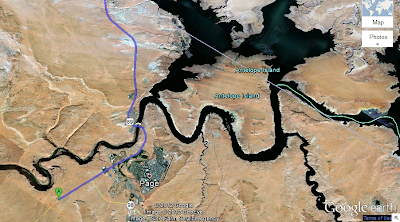
  Google Earth tracing our route to Kanab, on the phone.
 Horse Shoe Bend, City of Page, Lake Powell and the dam are visible.


The entire route - about 75 miles- to Howard Johns Hotel in Kanab.

Tomorrow Hoover dam, Lake Mead and flight back from Las Vegas.

Tuesday, September 25, 2012

Dy 2 Monument Valley- Arizona Utah border


  We are heading to see Monument Valley tomorrow and wanted to stay in the  nearest town called Kayenta, about twenty miles to its south. But rooms were all taken up,  and so at the days end in Grand Canyon, had to drive all the way to Flagstaff.


In the morning we drove through the desert road  from Flagstaff to Monument Valley.
  From Flagstaff, travel north on Highway 89 to Highway 160. Travel east on Highway 160 to Highway 163 (Kayenta exit). and  then take Indian Route 40 southeast to the entrance to Monument Valley. 


 In the heat of the desert stands the huge Utah good bye sign.


 Arizona state line.


 Under the sign board the heat is bearable.
After entering Utah,  on Route 163,  one has to re enter Arizona  by turning right , a few miles ahead  to reach monument valley welcome center. Admission to the park is $5 per person, and free for children under the age of 9.


The Valley is spread over a huge area (but the  park area is much small -  shown in green shade;  spread evenly across Utah (top) and Arizona (bottom)
But the neighboring Oljato Valley -   in pink - is fully inside Utah


Distant view of the visitor  center

At the visitor center, of Monument Valley  there is a souvenir shop of hand-crafted Native American Arts and Crafts, and a restaurant that serves Indian (American Native)  food.
Inside the cool restaurant operated by the native Indians, the outside heat is a deceptively distant. Alcohol free -  restaurant do not serve even beer or wine.    
The Monument Valley Navajo Tribal Park maintains a visitor center, campground, and restaurant. The  ramparts of the visitor center, offers a photo location. From the  Lookout Point  you will get a good views across three of the valley's most photographed peaks - East and West Mitten Buttes, and Merrick Butte. Butte is the rock formations standing high.

The view from Lookout Point is spectacular,  but most of the Navajo Tribal Park can only be seen by taking  the Valley Drive - a 18 mile dust road which starts at the visitor center and heads through the towering cliffs and mesas.


 The parking lot. One can drive the dusty roads of the valley in the cool comfort of the car; and get the close up view of the famous  peaks.


Typical journey around the loop takes about 2 hours. Tourists are not allowed to hike away from the road  towards any of the formations

  
Boiling - as the  desert sand may be, it is full of virulent life.  As I was taking the  picture of our  dust coated car, an ant sped up the legs and bit me by the knee. The bump etched and remained swollen for a couple of days.


Over the years, Monument Valley has been the setting for many Western movies than any other site in the United States. Unique sandstone formations, of the Navajo Indian Nation in Monument Valley define this vast, open desert region.


The place is an Indian reservation. More than 300,000 Navajo Indian Tribe people   live in the 16 million acre Navajo Nation.


The  theme song of one my favourite films Mackennas' Gold, "Old Turkey Buzzard",  was shot at Monument Valley. But the film was shot mainly at Glen Canyon, where  we will go, tomorrow.


Three sisters rock formation.


Some trees survive here.

Monument Valley was created as stones  eroded from the  Rocky Mountains, and was turned into sandstone. The formations you see in the valley were left over after the forces of erosion worked their magic on the sandstone for millions of years.

Wind and water then eroded the land, and the cracks deepened and widened into gullies and canyons, which eventually became the scenery you see today. Natural forces like wind and heat continue to shape the land.


Our   2.5 liter rented Nissan negotiated the dust roads without a hitch.
Here she is, dusty and hot like a ദോശക്കല്ല്