Monday, October 1, 2012

Hoover Dam & Las Vegas


Route from Zion Park to Hoover Dam. Distance  194 miles. ( 310 km )


 The  3hour 40 min  hour drive is mostly through barren deserts. But the good road and air conditioning  makes the trip a pleasure.


 Leaving the state of Utah and passing for a short while through Arizona, the winding road goes through   mountain passes on it way to enter Nevada State.  You hardly see anything green on the entire stretch.


 Nevada is more known for its Casinos than any thing else. Las Vegas is the internationally acknowledged capital of gambling business. Any one who comes here will spend at least an evening here. The city is also famous for shopping and dining.  We have planned our itinerary skipping Vegas. The airport is in the city, because the city has grown up to its periphery. Our plane back to New York is  at 10 pm and so after the Hoover Dam trip we'll come back, to return the car hired at Phoenix 4 days ago  and catch the flight home. May be we'll have dinner at a good place in Vegas.


 Mathew is straddling  two states - Arizona & Nevada. 
He collects the State Welcome Signs photos of all the visited US states and as we enter
 Nevada he'll have 32.
The heat of the desert at noon is unbearable to say the least.


 View of Lake Mead of Hoover Dam as we arrive from Henderson city after a late lunch.


 Before a new Bye pass was built on account of security concerns, US Route 89, crossed Colorado river  over the Hoover Dam. Point B on the map is the dam. The new bye pass is shown  in yellow.


  A huge bridge was built to bye pass the dam. From the side walk of this bridge you get a good perpective of the dam.


 Photo from the bridge. The resorvoir, dam and the power generators. Old road is on the left.
 Hoover Dam on the Colorado River is shared between Arizona and Nevada. It is  some 30 miles from Las Vegas. Constructed in the 1930s, it was intended to prevent flooding,  to provide irrigation in the desert  and hydroelectric power to  states like California and Arizona. 726 feet high and 1,244 feet long, Hoover Dam is one of the largest man-made structures in the world  and one of the world's largest producers of hydroelectric power.


Photo from the bridge.
Shade of the new bye pass bridge falls on a  section of the old road.  
The Federal Highway Administration, with the Arizona and the Nevada Department of Transportation , officially opened the new segment of US 93, known as the Hoover Dam Bypass, 
there by ending traffic over the dam. 
Vehicles began to run on, October 19, 2010. 


 The view from the other side-  across the dam straddles the new bridge 900 feet above Colorado river.


 Reservoir.
  The building of the dam created Lake Mead, which extends for 550 miles of shoreline and 247sq. miles of area,  one of the largest man-made lakes in the world. It has several recreational facilities. In providing recreational facilities Americans are second to none.


 Power generation water intake towers. Huge generators that could produce up to 3 million horsepower and provide electricity for three states.


Tribute to the workers who created the dam.


              Lake Mead look out point


End of our tour.  Back at Las Vegas the gamblers city. We planned to skip the city to give as much time as possible for nature tour. Just  have a couple of hours to reach the airport.


The  distinctive gold windows of these hotels get their colour from actual gold dust used in the tinting ... 
Opulence of this city has to be experienced, not described.

Sunday, September 30, 2012

Day 4 The last day of the Canyon Tour - Zion National Park


US ROUTE 89 from Page arrives at  Kanab, a small town where we lodged for the last day of the canyon tour. In the morning  we will ride through the Zion National Park ( green area, center of the map) and then take Interstate 15( transverse yellow road on the left of the map ) to Hoover Dam out side Las Vegas. From Vegas we'll fly back to New York by the 10 PM Delta Flight.


Typical sight on the road from Kanab to Zion Park


A Pizza joint just outside the Park.

 Welcome Sign. You can see the the beginning of the  typical limestone rocks.

   
 Entrance to the Park where you take the tickets for the car.

 Lime stone rock formations. You can ride the entire length of the park in your car
 and go out through the other entrance. Gaze up at massive sandstone cliffs of cream, pink, and red that soar into a brilliant blue sky.

 Even the roads is surfaced to match the colour of the enviorment.


 Travelers get out to make side tours through the Park to see water falls and valleys.
The Grand Canyon  is abut 150 miles to its south.
  Zion Canyon Scenic Drive and Echo Canyon are not far of the East Rim Trail.
You have to spend at least 3 days here to do justice to the place.


Zion National Park features stunning scenery, sandstone cliffs which are among the highest in the world, with diverse plant and animal communities. 
Once home to ancient Indian tribes  Puebloan & Paiute and later 
white Mormon pioneer settlers.

 I just don't know if these flowers are also seen sometimes on our roadsides. Looks so similar.
The Road passes through a couple of tunnels.

Samall tunnel, can see the other end


View from the inside of the longer tunnel


This tunnel has a side windows to the valley side
A few miles down the road, this opening can be seen from the valley below.

Outside
Winding road.
This is the  paths where ancient native people and pioneers of Americam settement walked.
Taking a picture of the tunnel window


Exit of the Park at the other end.


 The park is kept in a pristine condition. Zion’s unique range of plants and animals  will enchant you as you absorb the rich history of the past and enjoy the place that has hardly changed to the present day, except, perhaps for the good road. 

 On way to get into Interstate 15 to Nevada.

Wednesday, September 26, 2012

Glen Canyon, Page & Horse Shoe Bend- Aug 13.


 After the  Monument Valley tour we left for 
the Glen Canyon and Lake Powell Dam in the afternoon.
Driving on US 160 East, through the desert, the distance of about 175 miles was covered
 in 3 hours. In summer there is sun shine up to 9 PM. 
Enough time to see the Dam and the famous bend downstream.


When the Glen Canyon was bridged by a dam,  on the Colorado River, Lake Powell was created. This  also led to the creation of Glen Canyon National Recreation Area, a popular summer destination. Page is a small town created by the construction of the Dam.


 Glen Canyon bridge above Colorado river across the Canyon, just downstream of the dam.
The dam submerged a great canyon.  

 On the bridge. Glen Canyon Dam Bridge is a steel arch bridge in  U.S. Route 89 across the Colorado River. The bridge was built  to  transport materials for the Glen Canyon Dam, upstream.The  two lanes,  bridge rises over 700 feet (210 m) above the river.

 From the dam there is a 5 mile drive
 to the horse shoe meander ( വളവ് )

One has to climb a small hill and walk  down it,  about  ½-mile (0.8 km)  
from the parking lot on U.S. Route 89, to get there.

 From the hill top, the view of the  parking lot 
from where we set off. Further away the trucks ply on US 89.

  Far down in the center, you can clearly see the canyon created by Colorado river 
while taking the 270 degree turn.


Double click the pic to enlarge.

Horseshoe Bend is the name for a meander of the Colorado River,  near the town of Page.
It is located five miles (8.7 km) downstream from the Glen Canyon Dam
and its reservoir, Lake Powell - within Glen Canyon National Recreation Area.  
It's  view from the steep cliff above is fantastic. 
According to Google terrain maps, the overlook is 4,200 feet above sea level and the Colorado River is at 3,200 feet above sea level making it a 1,000 foot drop.


 Tourists take a safe viewing position.


 The size of the people  gives a perspective of the drilling work done by the river.

   A tired tourist from India.
The family picture atop the Glen Canyon.


 The vibrant color of the desert plateau as the Sun is calling it a day.


Passing  Lake Powell once more, as we are on way to Kanab, a small town in Utah,
 near Zion National Park, our next destination.

 
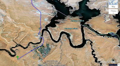
  Google Earth tracing our route to Kanab, on the phone.
 Horse Shoe Bend, City of Page, Lake Powell and the dam are visible.


The entire route - about 75 miles- to Howard Johns Hotel in Kanab.

Tomorrow Hoover dam, Lake Mead and flight back from Las Vegas.